
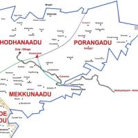
| As elaborated in the page on Badaga Hattis [villages], still there seems to be no conclusive evidence about how the ancestors made the divisions [geographical and social] about their villages.Simply put, in ancient times, a few houses (among brothers and cousins) formed a HATTI and then a cluster of villages, though based not only on the geographical locations, formed a OORU. Obviously, all the people from the hattis forming the Ooru were/are considered as brothers and sisters – and hence no marriages among these hattis were considered. Then, many Oorus formed a SEEMAY or NAADU. And, FOUR Seemays or Naadus form NAKKU BETTA – representing the complete Badaga population in the Nilgiri hills. Though, only three Naadus /Seemays namely, Thodhanaadu, Mekkunaadu and Porangaadu have the Dhodda Betta peak as the apex and common point of these three seemays, KUNDHEY SEEMAY, at the southern eastern end, is very much a separate and important seemay. See the map.
The confusion comes when we realise that some Thodha,Kotha and Kuruma villages/Oorus were also included into the broader periphery of Naadu/Seemay. The probable reasons for this inclusion could be the close association of Badagas with these tribes considered as the original inhabitants of the Nilgiris along with Badagas. Oorus forming Porangaadu Seemay ;
|

CONTINUE reading………..
Discover more from Badagas of the Blue Mountains
Subscribe to get the latest posts sent to your email.


 Mookuthi
  Chinna


 ==
==


![Seemae [See'may] & Morae [Mo'ray] (relationship)](https://i0.wp.com/badaga.wordpress.com/files/2008/11/nakku-betta1.jpg?resize=200%2C200)


Am glad to say that my book “Ancient Hindu Refugees” will be out in a year or so in A MUCH REVISED AND EXPANDED EDITION. It presents new evidence for a move from Mysore villages in the late 16th century, and brings the story completely up to date. Several people have been enquiring about how many hattis there are: well, in our Dictionary of Badagu (1992) we already gave the complete list of 468 hattis divided between a number of u:ru. That has not changed, although some of those hattis were abandoned.
LikeLike